
3D Urban Rendering Services for Urban Planning, Public Spaces and Modern City Development
Visualize the Unbuilt Cities to Empower Urban Change
Meet Our Boutique 3D Visualization Studio to Visualize Lifestyle-Focused Scenes
RNDR is a small, bespoke 3D visualization firm that creates storytelling 3D renderings for city planners, real estate developers, and public authorities to help them bring their vision to life. Our team brings architectural training with a human touch 3D visualization, thinking about how buildings are going to feel in the real world rather than just looking at blueprints. Unlike the generic, fast-tracked AI churn out there, we focus on crafting 3D images that genuinely capture the atmosphere of a place.
Founded in 2017 and based in Warsaw, we work globally across Europe, America, and the Middle East on projects ranging from metropolitan-scale master plans to local revitalizations, our CGI support clients like NEOM, Utrecht Municipality, and WEST 8, as well as local teams, shaping cities around the world.
Urban 3D Rendering Studio Trusted by Urban Planners, Architects and Developers


Client Reviews: Why Clients City Architects and Urban Planners with Us

Our Examples of Architecture Renderings for Urban Spaces


Let’s shape the right visuals for your project
Bridge Planning & Public Understanding
Making the Leap from Planning to Execution with 3D
These days a good 3D rendering is no longer an optional extra, it’s a must-have in the planning world. And it’s not hard to see why. Having a realistic 3D picture of what you’re planning lets people instantly get a handle on how the zoning, flow and overall design all fit together.
A properly thought-out visualization is a powerful tool that helps to inform, inspire and win over stakeholders at every stage. And when it comes to getting your city planning out there and getting people on board with your public engagement process, a well-crafted 3D rendering can make all the difference.
Our Professional 3D Architectural Rendering Services for Town Planning
Every city planning project is one of a kind and so is the visualization it requires. That’s why as an architectural visualization company we offer a range of specialized 3D services tailored to your urban project-specific needs. Such rendering must accurately reflect the architectural designs, eco-friendly planning, and city development. Choose from our range of 3D solutions to communicate your town planning and design from the ones below:

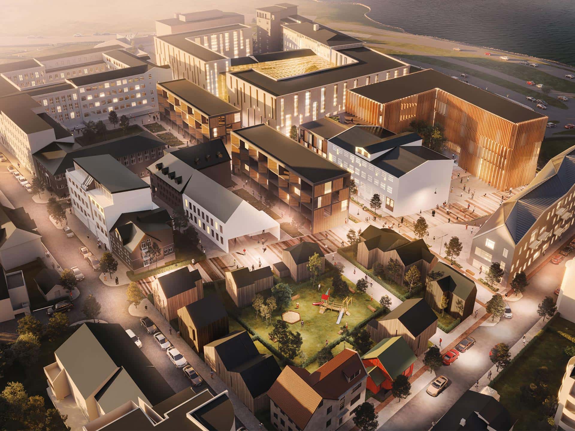
Get a comprehensive 3D view of large-scale developments: how buildings, streets and infrastructure all fit together within the urban landscape, and what the view from the top looks like.
Use our advanced 3D renderings to show off how public spaces and streets work in your master plan: where people walk, where green spaces are, and where community facilities are.

Use our 3D rendering to make proposed urban projects understandable and engaging, so the community can give you their feedback.
Bring urban landscapes to life with realistic 3D details, and show everyone what your eco-friendly planning will look like in real life, not just in sketches.


Rendering in Urban Planning Tenders, Pitches and Bids
Large-scale urban 3D visuals can really make your tender submissions stand out: show stakeholders exactly how your design fits with the planning regulations.
City Design 3D Aerial View Rendering Services
These are all about fitting in with the rest of the city and seeing the entire urban transformation at a glance: perfect for site planning, zoning proposals and more.

Which one fits your project best?
Convey Your Master Plan in Seconds
Visualize the Core of Your Urban Designs
Using 3D renderings makes complex ideas easier to grasp at a glance. Urban visuals allow planners and designers to communicate their vision instantly, helping all participants, from residents to local governments, understand the impact of future developments.
By using 3D artists to illustrate all the design decisions that have gone into a project, you’re not just making it easier for people to understand but also fostering a dialogue that’s going to be useful to everyone involved. You’ll get smoother approvals and better outcomes for your project.
Our Urban Design Rendering Services: Choose the Right 3D Solution for Your Project
As a seasoned 3D architectural visualization studio, our work gives planners, municipalities, and developers the visual ammunition they need to get their message across, build trust with the public, and make informed decisions about building better cities. Let’s explore the different types of urban visuals we can bring to the table:

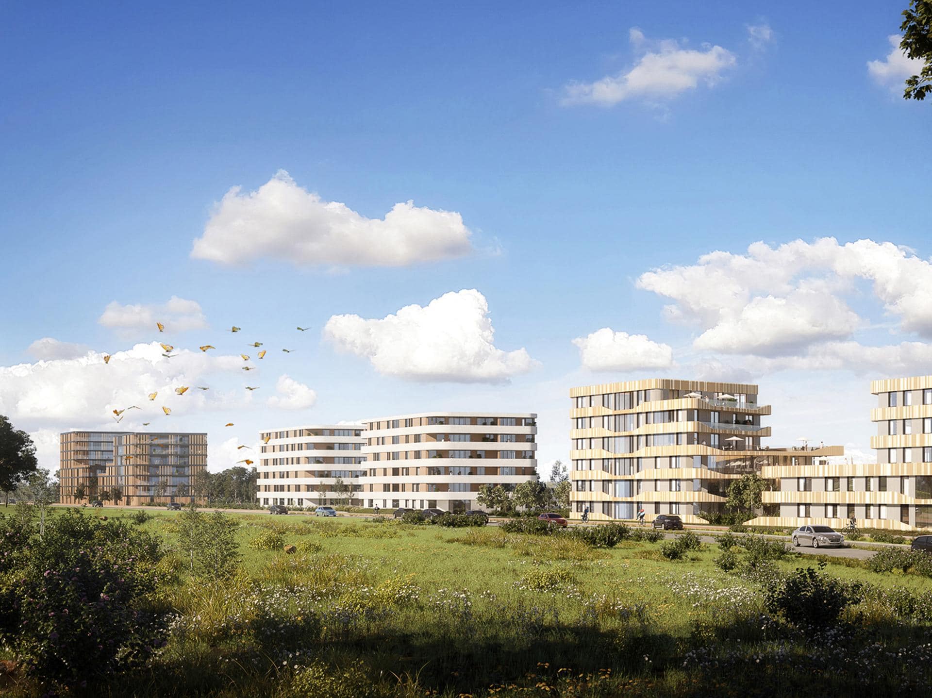
We can help you show off the potential of retail districts, office hubs, and transit-oriented developments in a way that gets investors excited, speeds up the approval process, and gets all stakeholders on the same page. Our cityscape renderings are perfect for presentations, investor pitches and any other situation where you need to get your project moving.
We can also use our skills to bring civic spaces like parks, plazas, streetscapes, and public institutions to vivid life in a way that builds trust and gets people excited about participating in the planning process. Our public realm renderings are ideal for public consultations, design tenders, and any other situation where you need to get your message across to a wider audience.


We can support you in showing the potential of housing developments, urban infill and large-scale residential zones in a way that makes scale, density, infrastructure and liveability instantly clear and compelling. Perfect for marketing, real estate listings, tenders, community engagement and anything else where you need to get your project message out there.
What are your rendering needs?
Why 3D Rendering Is Essential for Modern Urban Planning?
3D rendering has become a complex tool that don’t just show a future city as photorealistic 3D, but it lets people actually experience it, get a feel for navigating it, and get a real sense of its impact on urban growth. As a specialized urban 3D studio, we take master plans and turn them into compelling, story-based 3D renderings that bring your urban ideas to life in a way that makes it easy to clearly communicate your planning. Here are the key benefits of using high-quality cityscape renderings by planners to shape better cities:
Leverage Planning Through Visual Storytelling
Reveal the Urban Future Before It’s Built
What makes a rendering truly powerful is its ability to bridge the gap between a visionary plan and how people feel and understand it. When a rendering gets the atmosphere, the materials, the details and even the people in it just right it can draw people in and carry them along the narrative of the space.
With accurate 3D renderings you’re not just presenting a project, you’re shaping how people see the future. And better visuals lead to better cities.
Our Urban Planning Rendering Process
Experience drives our workflow that can take even the most complicated urban design concepts and turn them into vivid, story-driven 3D visuals that grab attention. Want to see how we do it? Keep on reading to learn more about our process.
Getting Your 3D Rendering Project Started
First things first, we’ll need to get to grips with what you’re after by filling in our 3D project brief. This gives us a clear idea of the scope, what you’re looking to achieve and what your expectations are. Once we’ve got that sorted we’ll send over a tailored quote, along with a list of what files we need from you to get things underway.
Watching Your Urban Design Renderings Take Shape
Now comes the fun part seeing your design come to life in 3D. We typically come up with 2-3 camera angles for you to choose from and from there we work up a first draft of your renderings. We then do 2 rounds of revisions (we usually have your revised images back to you within 2-5 business days) before fine-tuning final details based on your feedback.
The Final Result: High-Quality Urban Renderings
The end result? High-quality images that are ready to drop straight into your presentations, approvals or marketing materials.
Get Your Quote and Get Started
Fill in the 3D project brief form, and we’ll send you a quote for the 3D rendering work you need.
Our Architectural 3D Visualization Portfolio
Get a closer look at our portfolio and see just what we can do with high-quality 3D architectural renderings. We don’t just bring your designs to life, we also give a sneak preview of what you can expect from your finished project because each rendering tells the unique design story, providing a vivid snapshot of what will come.
Frequently Asked Questions – FAQ
Public realm and city planning projects often come with a lot of moving parts, stakeholders, and presentation challenges. That’s why clients usually have questions before starting. Below, we’ve answered some of the most common things we get asked about.
How do you choose the right 3D rendering services partner for urban projects?
The right approach depends on the project goal. Some urban spaces visuals are created for planning approvals, others for public engagement, investor presentations, or marketing. We usually recommend visuals that not only explain the design clearly, but also show how people will actually experience the space.
What makes an effective urban planning rendering stand out?
An effective rendering in urban planning does more than showcase buildings. Urban 3D rendering is essential to communicate context, human activity, atmosphere, and how the development connects with the surrounding city and public life.
What exactly are 3D urban design rendering services?
These urban planning rendering services involve creating visual representations of metropolitan design, infrastructure planning and modern urban development projects with help of rendering software. These detailed 3D visualizations help developers, city architects and urban planners present complex urban design layouts and 3D models of buildings, infrastructure, public areas, and overall spatial relationships in a clear and understandable way.
Architectural 3D rendering services transform urban environment design concepts into 3D site plan renderings, 3D streetscape rendering and 3D exterior renderings as eye-level and bird’s-eye views. They are commonly used for planning approvals, stakeholder presentations, public consultations, and large-scale development communication, helping teams visualize how future urban environments will look and function.
Can architectural CGI do anything to help when talking public spaces and getting local nods of approval?
Absolutely, it can. Architects often use CGI to spice up presentations, competitions, meetings and approval processes by making these big ideas that little bit more tangible and a whole lot more interesting to discuss.
Why does architectural visualization in urban planning matter nowadays?
Urban projects can be a right challenge to communicate with a drawing alone. CGI helps everyone: councils, community groups, village halls and decision makers get a feel for the scale, the mood, how people will move through the space and how it’ll all hang together in real life.
Didn’t find the answer you were looking for? No problem. Every project is different, and we’re always open to talk. Feel free to get in touch with us.
Start Your Urban CGI Journey with Our 3D Rendering Company

Malgo Widaj
Founder of RNDR
Contact us today and let us show the future of your city before it’s built.