
Supporting Planners and Urban Designers: The Power of Urban Planning Renderings
Urban planning renderings are vital tools and services for presenting urban landscapes and public spaces, serving architects, planners, urban designers, and developers to visualize their urban space development proposals. In urban environments, where designs are complex, these digitally advanced tools powered by rendering software, offers a level of precision and clarity in presentation and informed decision-making that traditional methods simply cannot match.
The use of urban renderings significantly enhances the public space planning and design process. Urban planners can assess the feasibility of their urban designs, identify potential issues, and make necessary adjustments before construction begins. Furthermore, urban 3D visualizations help city officials and community members visualize the proposed changes, building greater transparency and trust in the planning process.
Urban renderings not only enhance the design process but also play a crucial role in infrastructure planning and construction management as analysis tools. These tools provide a clear visual representation of the project, aiding in the presentation and communication of urban design projects, ensuring alignment toward a common goal. This level of understanding and informed decision-making is essential for the successful execution of compound projects, including their traffic flow through infrastructure projects and environmental impact, where even minor discrepancies can lead to significant delays and cost overruns.

Residential living at Kloos Alblasserdam, Netherlands / Architects, urban designers, and developers: FSD x Bosch und Slabbers x Van Aken / 3D aerial view rendering crafted by RNDR
Why Old-School Master Plans Are Failing Us
Traditional urban planning presentation methods are increasingly falling short in addressing the demands of communication processes in modern urban environments. The limitations of old-school master plans are becoming evident as cities continue to evolve at a rapid pace.
One of the primary elements missing from traditional urban planning projects is the ability to visualize and simulate different urban planning scenarios. Without this capability, urban designers are forced to rely on highly technical maps and drawings, which can be challenging to interpret and often fail to convey the nature of urban spaces in an understandable way to non-professionals. This lack of a user-friendly visual representation tool makes it challenging for stakeholders to fully understand the implications of proposed urban projects, leading to misunderstandings and resistance.
Moreover, urban space renderings offer a comprehensive approach, allowing urban designers and planners to consider all aspects of the urban design proposal, including architecture, public spaces, and infrastructure projects by presenting functional and sustainable designs in an understandable way.
Visualizing Technical Language of Urban Design: A Common Language for Urban Planners, Architects, and Developers
One of the most significant benefits of urban design renderings is their ability to bridge the communication gap between diverse teams and all parties involved. In the complex world of urban design, architects, urban designers, and real estate developers often speak different languages of expertise. This can lead to misunderstandings and misaligned goals, ultimately hindering the success of public spaces and urban design projects. However, urban design renderings provide a common visual language that everyone can understand, fostering better collaboration and more effective decision-making.
Visual representation of project outcomes plays a crucial role in the urban design process, allowing urban planners to convey complex public spaces and urban design concepts in a clear and comprehensible manner. By outsourcing detailed urban visualizations, planners can effectively communicate their ideas to city officials, community members, and other stakeholders through visual communication. This secures effortless collaboration and a smoother creative process. This not only helps to build consensus but also ensures that everyone involved has a clear understanding of the project’s goals and objectives.

Beurskwartier, new city center in Utrecht, Netherlands / Urban planners: Urbanext + Utrecht Municipality / Urban planning rendering crafted by RNDR
From Concept to Execution: How Urban Renderings Bring Ideas to Life
The journey from concept to execution in public spaces and urban design planning is fraught with challenges, but urban renderings make this transition smoother and more efficient. These services enable urban designers and city planners to outsource realistic visualizations of their urban design projects, making their ideas tangible and actionable.
The transition from design concepts to construction projects is further facilitated by the use of Building Information Modeling (BIM). BIM is an urban design software used by urban planners to create a comprehensive digital representation of the project, incorporating all relevant data and information. This holistic approach ensures that all aspects of the project are considered, from the initial design to the final construction, enhancing building performance. BIM helps to coordinate the efforts of various teams, ensuring that everyone is aligned and working towards the same goal.
Urban visualizations also play a crucial role not only in the urban planning process but also in city management, helping to streamline project workflows and improve coordination. These tools offer a clear visual representation of urban design and its spatial relationships, facilitating the identification of potential issues and enabling necessary adjustments before implementation.
Breaking Down Barriers: Improved Collaboration Through Urban Design 3D Visualization
Urban design 3D visualization is breaking down barriers and fostering a collaborative approach. Visual feedback transforms the design process, allowing team members to see and understand each other’s ideas more clearly.
Visual representation is an essential tool that enables urban designers and city planners to outsource urban design renderings and showcase spatial relationships of public spaces and urban landscapes. This level of detail is crucial for fostering collaboration, as it ensures that everyone involved has a clear understanding of the project’s goals and objectives. By providing a tangible representation of the proposed changes, a 3D urban design representation enables users to see the future proposal and helps to build consensus and align the efforts of various teams.
Project management and workflows are also significantly improved through the use of urban design 3D visualization by urban planners and city designers. These tools offer a clear visual representation, aiding in the coordination of the efforts of various teams to ensure everyone is aligned and working towards the same goal. This level of coordination is essential for the successful execution of complex urban design projects, where even minor discrepancies can lead to significant delays and cost overruns.

Sustainability image of the future / Architect: Sweco / Urban planning rendering crafted by RNDR
Selling the Vision: How Urban Renderings Win Stakeholder Support
Urban renderings play a pivotal role in securing stakeholder support by providing visual representations that effectively communicate the urban design and goals of the project. These visuals are instrumental in securing investment and community buy-in, ensuring that the project has the necessary support to move forward.
Urban design visualizations help to engage the community by providing a clear and compelling representation of the proposed development. This level of transparency fosters trust and confidence in the planning process, encouraging community members to actively participate and provide valuable feedback.
By showcasing the project’s benefits in a clear and compelling manner, urban renderings help build consensus and secure the necessary support from stakeholders. Urban renderings provide a tangible representation of the project, making it easier for stakeholders to visualize the impact on the urban environment. This not only helps to build consensus but also ensures that everyone involved has a clear understanding of the project’s goals and objectives. By providing a detailed and accurate visual representation of the proposed projects, urban renderings help to secure investment and community buy-in, ensuring that the project has the necessary support to move forward.
Building Better Cities: Supporting Sustainable Urban Development with 3D Renderings
3D renderings have transformed the way urban planners approach sustainable urban development. These tools enable planners to outsource urban design visuals, helping stakeholders make informed decisions about city development. 3D renderings offer a clear and compelling representation of the proposed development, aiding in the building of consensus and securing stakeholder support.
One of the key benefits of 3D renderings is their ability to showcase eco-friendly design elements, such as green roofs and renewable energy systems, in urban projects, including green spaces. These visuals help to communicate complex environmental consideration strategies in a way that is engaging and easily understood by stakeholders, fostering greater community and investor buy-in for urban development initiatives and energy consumption while also highlighting the environmental impact.
Educational opportunities provided by 3D renderings are also significant. These 3D services help to illustrate eco-design principles to future architects and the public, fostering a greater understanding of sustainable urban development.
The use of 3D renderings in urban planning also helps to speed up governmental and community approvals by presenting understandable urban planning visuals that clarify the urban designer’s intent. This level of common understanding is essential for the successful execution of urban planning projects.
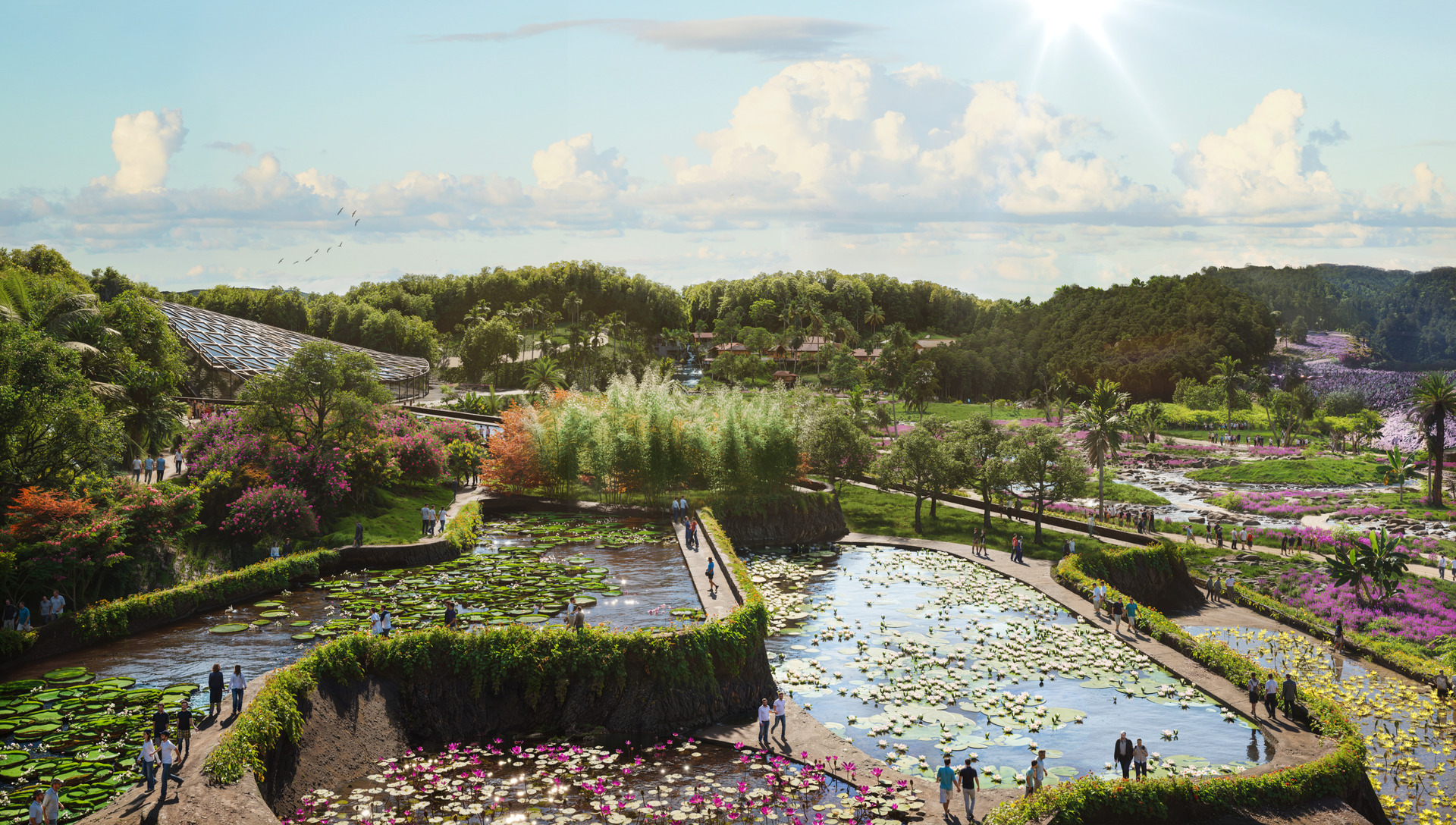
Botanical garden master plan at Kadambur, near Maraimalai Nagar, Chengalpattu District, Tamilnadu, India / Landscape and urban planner: WEST8 / 3D urban planning rendering from aerial view crafted by RNDR
Winning Buy-In: Improving Stakeholder Engagement and Public Participation in Urban Planning Projects
Winning the support and active participation of the community is a cornerstone of successful urban planning. However, many urban planners struggle to effectively incorporate community feedback into their decision-making processes. Urban renderings provide a solution by making it easier to visualize and understand the functional and environmental impact of proposed developments, thereby improving feedback and community engagement.
Establishing a comprehensive system for archiving public input can greatly enhance the accessibility of community feedback across planning departments. This ensures that valuable insights gathered from community engagement initiatives are not lost and can be effectively integrated into the planning process. Clear communication about the limitations and context of planning projects can also significantly reduce irrelevant public feedback, making the engagement process more efficient and productive, and enabling data-driven decisions to be made.
Effective urban planning survey design is another critical component of social participation processes. By focusing on the specific needs of final users, planners can gather more relevant and actionable feedback from the community.
With 3D renderings improving, public feedback on planning systems can help mitigate community frustration and reduce the frequency of new surveys about future urban projects. This not only fosters a more collaborative and inclusive urban planning process but also helps to build trust and confidence in the project, leading to more informed decision-making.

Residential living at Kloos Alblasserdam, Netherlands / Architects and developers: FSD x Bosch und Slabbers x Van Aken / 3D urban planning rendering crafted by RNDR
Final Thoughts on Urban Collaboration and City Planning with 3D Urban Renderings
Urban planning renderings foster enhanced collaboration among urban planners, architects, and developers by providing a common visual language. This collaborative approach is essential for creating sustainable cities that can adapt to the evolving needs of modern urban environments.
In conclusion, urban planning renderings are the ultimate tool for building tomorrow’s resilient urban spaces together. They provide a common visual language for proposed innovative solutions in development, fostering collaboration, enhancing stakeholder engagement, and enabling informed decision-making. They are a powerful tool that provide the clarity, precision, and transparency needed to navigate the complex world of urban planning and to create urban environments that are functional, beautiful, and sustainable. By leveraging these powerful tools and 3D services, urban planners, architects, and developers can create urban environments that are not only functional and efficient but also vibrant and resilient.
Need Professional Urban Design 3D Renderings That Make an Impact?
Contact us by clicking below and provide your project details to get started.
