
A 3D master plan rendering does a different job at each step of the approval process. At concept stage, it tests massing and density for the design team. During public consultation, it shows residents their own streets. At the council vote or permit stage, accurate views give planning boards evidence they can check before they approve.
Master plans usually stall where people can’t picture them, so this guide shows where eye-level images and aerial view rendering services help at each stage.
What’s in This 3D Master Plan Rendering Guide?
- What Is 3D Master Plan Rendering in Urban Development?
- Why Does 3D Masterplan Urban Design Rendering Struggle To Win Public Trust?
- How 3D Master Plan Renderings Work at Each Stage of Approval
- How Do Architectural Master Planning Renderings Support Public Participation?
- What Must Architectural Master Planning Visuals Show a Planning Committee?
- Take Your Master Plan Into the Hearing With Images People Believe
- FAQ About 3D Master Plan Renderings in the Approval Process
- Sources
What Is 3D Master Plan Rendering in Urban Planning?
A 3D master plan rendering is a visual of a whole district, campus or neighborhood before it exists. It takes the master plan, with its building footprints, heights, streets, green spaces and phasing, and turns it into images people can read at a glance: aerial views for the big picture, eye-level views for how a street will feel. In the planning and approval process, it does a job drawings can’t. A 2D plan tells planners what goes where. A rendering shows residents, council members and investors what it will be like to live there.
It sits at the end of a long chain of drawings. A site plan is a measured drawing of the project site, with property lines, access points and levels. A zoning diagram shows where residential areas, mixed-use districts and industrial zones will go.
A 3D master plan rendering brings the terrain, buildings, landscaping, roads, water and light together in one model, so the site looks the way it will in real life. A site plan rendering gives a top-down 3D view of a single plot, with the camera at 90 degrees so the layout stays clear. The difference in site plan rendering vs master plan rendering is scope: one property versus a whole district, often built in phases. A three-dimensional master plan rendering also works from many camera positions. Aerial views give the overview of building heights, public spaces, urban density and the spatial relationships between new buildings. Eye-level views show how a street will feel to the people who walk it. Many residents find flat plans hard to read, and these views give them something they can understand.
This article stays with one question: what the images do once a plan leaves the design team and enters public life.


Beurskwartier, the new city centre district in Utrecht, Netherlands / Designers and architects: Urbanext + Utrecht Municipality / Street-view and aerial renderings created by RNDR
Why Does 3D Masterplan Urban Design Rendering Struggle To Win Public Trust?
Because most people have seen renders of master plans before. Almost everyone who comes to a consultation evening has watched at least one scheme in their town arrive looking nothing like its brochure. They bring that memory into the room, and every image you show gets measured against it.
This is the strange position masterplan urban design is in. The images are more convincing than ever, and residents trust them less than ever. Better tools didn’t fix that, because the problem was never the quality of the CGI. It was what the images chose to leave out.
The Glossy Render Problem
The glossy render has a look everyone recognizes. Golden hour. Trees that are 30 years old on opening day. Empty streets, no parked cars, no bins, no bus stop. It works in a sales brochure. At a public hearing it reads as a sales pitch, and residents start wondering what else has been edited out.
Aesthetic appeal isn’t the issue. Visual appeal is part of what makes people care about a plan. What hurts is beauty that comes from removing reality: the traffic that disappears, the shade that never falls on the neighbors’ gardens, the six years of construction nobody shows.
AI tools have made this harder, not easier. An AI render can produce a lovely tree-lined street in seconds, and masterplan AI platforms can fill a slide deck by lunchtime. But each AI image is generated on its own, so building heights and distances can drift from one view to the next. A planner who spots one wrong height stops trusting the other twenty images. That’s the difference between a quick AI image and professional rendering: photorealistic visuals with no model behind them are the fastest way to lose a room.


Public spaces in Enschede, Netherlands / Landscape architects: ZUS [Zones Urbaines Sensibles] / Aerial master plan visualization of the green public spaces between historic villas and new towers, with a church spire as a landmark on the skyline, and an eye-level evening view of the square, created by RNDR
What Residents Fear vs. What They Are Shown
Residents rarely ask about architecture. They ask whether the new block will shade their garden, where 600 new cars will park, whether the bus will be full, and what happens to the field where their kids play football. Most master plan presentations answer a different question: how the scheme looks from 300 meters up at sunset.
When an image doesn’t answer the fear, the fear fills the gap. Someone at the back of the room imagines a wall of towers, and by the end of the evening that’s the version the neighborhood talks about.
The fix is to show what people are worried about, on purpose. Put a camera on their side of the street. Show the junction at 8 a.m. Show the new block next to the low-rise housing it faces, in November, when the sun is low. It feels risky to developers the first time. In our experience it’s the images that look most honest that earn the most public support, because they prove nobody is hiding anything.
Show the master plan from the neighbors’ side of the street, in November light, and let the images answer their questions and fears before they appear.
Malgo, CEO of RNDR

How 3D Master Plan Renderings Work at Each Stage of Approval
Approval isn’t one meeting. It’s a chain of them, and the images have to change as the stakeholder in the room changes. The rules differ from city to city. In New York, a rezoning passes through the community board, the borough president, the City Planning Commission and the City Council, one after another. In British Columbia, residential rezonings that match the official community plan no longer get a public hearing, so public input moves to the plan updates instead. In the Netherlands, permit applicants have to explain how they involved the people around a project. In London, tall buildings arrive at committee with verified views. The sequence underneath is similar almost everywhere.
Key fact: New York’s standard Uniform Land Use Review Procedure (ULURP) takes about seven months: 60 days at the community board, 30 days with the borough president, 60 days at the City Planning Commission and up to 50 days at the City Council. In November 2025, voters approved a faster track (ELURP) for smaller housing and infrastructure projects, with a 30-day City Planning Commission review and no City Council step for most applications (Ballotpedia, 2025).
That’s four public reviews, each with a different audience, and the community board comes first. New York’s 59 community boards each speak for tens of thousands of residents, and for many of them that meeting is the first time they see the project. A colored zoning diagram on a screen looks like just a map.
Concept and Feasibility
At the start, the audience is small: the design team, the developer, maybe an investor and an informal first meeting with the city architect. The question is simple. Does this fit the site? Not every scheme will need a master plan image set this early, but on large sites the first views pay off quickly.
This is where speed matters more than polish. A white massing aerial is enough to test the project’s scale, the road networks and the urban layouts against the surroundings. A first massing plan rendering takes days, not weeks. Urban planners use the same 3D model to test shadow casting, traffic circulation and pedestrian flow long before construction starts, while changes still cost nothing.
It’s also where AI tools make perfect sense. An AI site plan generator can test five urban layouts before lunch, and AI masterplan rendering can turn a hand-drawn masterplan sketch into a mood image for an internal workshop. AI transforms how fast a team can compare early options when creating a master plan. Those images should stay inside the building, though. The moment a view goes in front of the public, it has to come from a checked 3D model.
Public Consultation and Workshops
Public consultation is where the audience gets large and the camera gets low. Residents need eye-level views from places they know, before and after pairs, and a fair comparison when you’re asking them to choose. A full master plan rendering set usually takes two to three weeks from complete files, so book it before the consultation date is announced.
The format matters as much as the image. On a study walk, a printed view held up at the exact corner it shows does more than any slideshow. At an open evening, large high-resolution boards let people stand close and point. Online, the same images reach the parents and shift workers who never come to a town hall. A good master plan visualization is a communication tool that works in all three settings.


Living at Langeweg, Hoek van Holland, Netherlands / Developer: Van Omme & de Groot / Design: LAP Landscape & Urban Design and Groosman Architecten / Aerial rendering of 150 apartments between the village, the dunes and the beach, and an interior visualization with a bird’s-eye view from the window, created by RNDR
Planning Committee and Final Approval
By the time a scheme reaches the planning committee, the images become evidence. Council members, planning officers, and heritage and transport officers want accurate views from agreed points, a clear phasing sequence, and images that match the submitted architectural drawings exactly. In many cities, the planning commission asks for 3D visualizations to check a scheme against local building codes and design standards, so these master plan renderings are part of the file, not an extra.
Consistency plays a critical role at this stage. Designs change in the last weeks before a municipal submission, and an image that was right in March can be wrong in May. A committee that finds one view out of date will start doubting the rest. Keeping every image tied to one model, updated with each revision, is the cheapest insurance a developer can buy. In our workflow, ideally a design change updates the model once, and the post production in Photoshop is redone only where the change shows, so the whole project stays in step from blueprint to final image. Updating one model instead of redrawing every view also keeps the schedule safe in the weeks before a hearing.
After Approval: Phasing and Off-Plan Sales
Approval is where most teams stop thinking about the images. It’s also where the 3D model starts paying for itself a second time.
The same model can feed the sales campaign, client presentations, the construction hoardings and the updates neighbors receive during years of building work. For a residential development, a photorealistic masterplan visualization of the finished neighborhood often becomes the anchor of the sales suite, and each amenity, from the playground to the rooftop garden, gets its own view. Because the model already exists, presentation ready visuals for sales take weeks, not months. What changes is the layer on top. For off-plan sales, we add what the approval images deliberately left out: the season the buyers would fall for, the people the homes were designed for, the development’s name on the canopy. Approval images prove the plan is acceptable. Lifestyle images make someone want to live there. Both should come from the same model, so the story never contradicts itself.
Stage |
Who’s in the Room |
What They Need To See |
Best View Type |
Common Mistake |
Concept and feasibility |
Design team, developer, investor, city architect (informal) | Massing, density, access, whether the numbers fit the site | White or clay massing aerials, quick option studies | Polishing images before the layout is stable |
Public consultation and workshops |
Residents, local businesses, community groups, participation officer | Their own street, shade, green space, traffic, what stays | Eye-level views from known places, before and after pairs, option comparisons | Showing a marketing hero shot to worried neighbors |
Planning committee and final approval |
Council members, planning officers, heritage and transport officers | Heights, massing and shadow from agreed points, phasing, consistency with drawings | Verified views, accurate aerials, dated phasing sequence | Images that no longer match the submitted drawings |
After approval: phasing and off-plan sales |
Buyers, tenants, sales team, neighbors living through construction | What daily life will be like, what gets built when | Lifestyle and storytelling renders, branded views, dated phase aerials | Starting sales visuals from scratch instead of the approved model |
A late or inconsistent image set can derail a hearing. Bring your master plan to a team that keeps every view matched to the latest drawings, on schedule.
Malgo, CEO of RNDR
How Do Architectural Master Planning Renderings Support Public Participation?
Master plans only get useful public input when people understand what they’re commenting on. Without images, consultation turns into a contest between the few residents who can read technical drawings and everyone else, who has to guess what the drawings mean. We’ve looked at why architectural renderings are useful in citizen participation processes before. This is where architectural visualization earns its place in a planning file, and here’s how it plays out in master planning.
Key fact: A 2023 review of 46 case studies in Landscape and Urban Planning found that only four had used 3D visualizations in an actual planning process, while the rest stayed at prototype or pilot stage (Eilola et al., 2023). Developers who bring a clear aerial view to the table are still the exception.


Urban design project 2330, Theoretikum medical campus, Halle (Saale), Germany / Architects and planners: ASTOC Architects and Planners / Paper-model-style aerial rendering of the campus and a detailed eye-level view showing how the place will feel to the people who use it, created by RNDR
A Communication Tool for Non-Professionals: Views From Familiar Streets
Most residents can’t read 2D site plans, sections or a floor plan, and there’s no reason they should. Picture a retired bus driver at a consultation table: he knows every corner of the neighborhood, but a hatched rectangle on a drawing tells him nothing about whether his street will feel different.
An eye-level view taken from that corner tells him at once. Here, a master plan rendering acts like a translator between the drawings and the street. That’s why camera angle is the first decision we make for consultation images. We place cameras at 1.6 meters, at the bakery, the school gate, the bus stop, the edge of the park. People recognize the place before they look at the new buildings, and that recognition is what makes the image credible. A visual representation is the nearest thing planning has to a universal language, which matters in neighborhoods where many residents don’t read planning jargon in any language. We wrote more about this in our article on designing inclusivity with architectural renderings in citizen participation
A Democratic Tool for Urban Projects: Options Instead of Yes or No
A single image asks for a verdict. Two images ask for an opinion. When residents see massing option A next to option B, or two layouts for the new park, the conversation shifts from “we don’t want this” to “this one, but with more shade over the playground.”
That shift matters for who speaks up, too. Clear visual elements bring in people who usually skip consultations: younger residents, parents, non-native speakers, people who feel a planning meeting isn’t for them. Their feedback is often more practical than the loudest voices in the room. We’ve seen how this changes the result in our piece on inclusive design processes with inhabitants.
Key fact: Since the Dutch Environment and Planning Act (Omgevingswet) took effect on January 1, 2024, permit applicants must state whether and how they involved the people around a project and whether it changed anything. Dutch courts have since confirmed that participation doesn’t require consensus (Greenberg Traurig, 2024).
That’s a useful reminder for developers. The point of showing options isn’t to let the public design the scheme. It’s to show that their input was asked for, understood and, where it made sense, built in. A pair of before and after option images is the simplest proof a permit file can contain.

Green future concept / Architect: Sweco / Overhead rendering showing how buildings and nature meet, created by RNDR
Communicating Urban Transformation: Before, During and After
Urban transformation is hard to picture because it happens over years. A before and after pair from the same camera angle answers the first question most people ask: what happens to what’s here now? Residents see the car park become a square, or the fenced brownfield become new parks and landscaped courtyards. If something they value stays, like an old tree, a chapel or a row of shops, show it clearly in both frames.
The “during” image is the one almost nobody makes, and it’s the one neighbors worry about most. What will the street look like in year three, with half the blocks built and cranes on the rest? Showing it honestly takes the edge off the disruption, because people can see that it ends. It turns the long-term vision of a future city district into a sequence they can follow, one phase at a time.
Real Seasons, Real Neighbors, Real Daily Life
When we’re creating a master plan rendering for consultation, this is where we spend the most thought, and where the image stops being a diagram. A real visual story needs real conditions. A November evening at five, when the streetlights are on and the walkway along the new park is wet. A bench in winter sun. Kids walking to school in March.
The people matter as much as the light. A neighborhood of older residents and young families shouldn’t be shown full of stock-photo commuters in sunglasses. We pick people, local car models and even plates that belong to the place, and a landscape character that fits the region, with realistic landscaping at five years, not fifty. Landscape designers often tell us this is the first time their landscape design looked like something people would use.
None of this is decoration. When a resident sees their own kind of life in the image, they start judging the plan as a place to live, not as a threat. That’s what a rendering brings to participation that no drawing can.
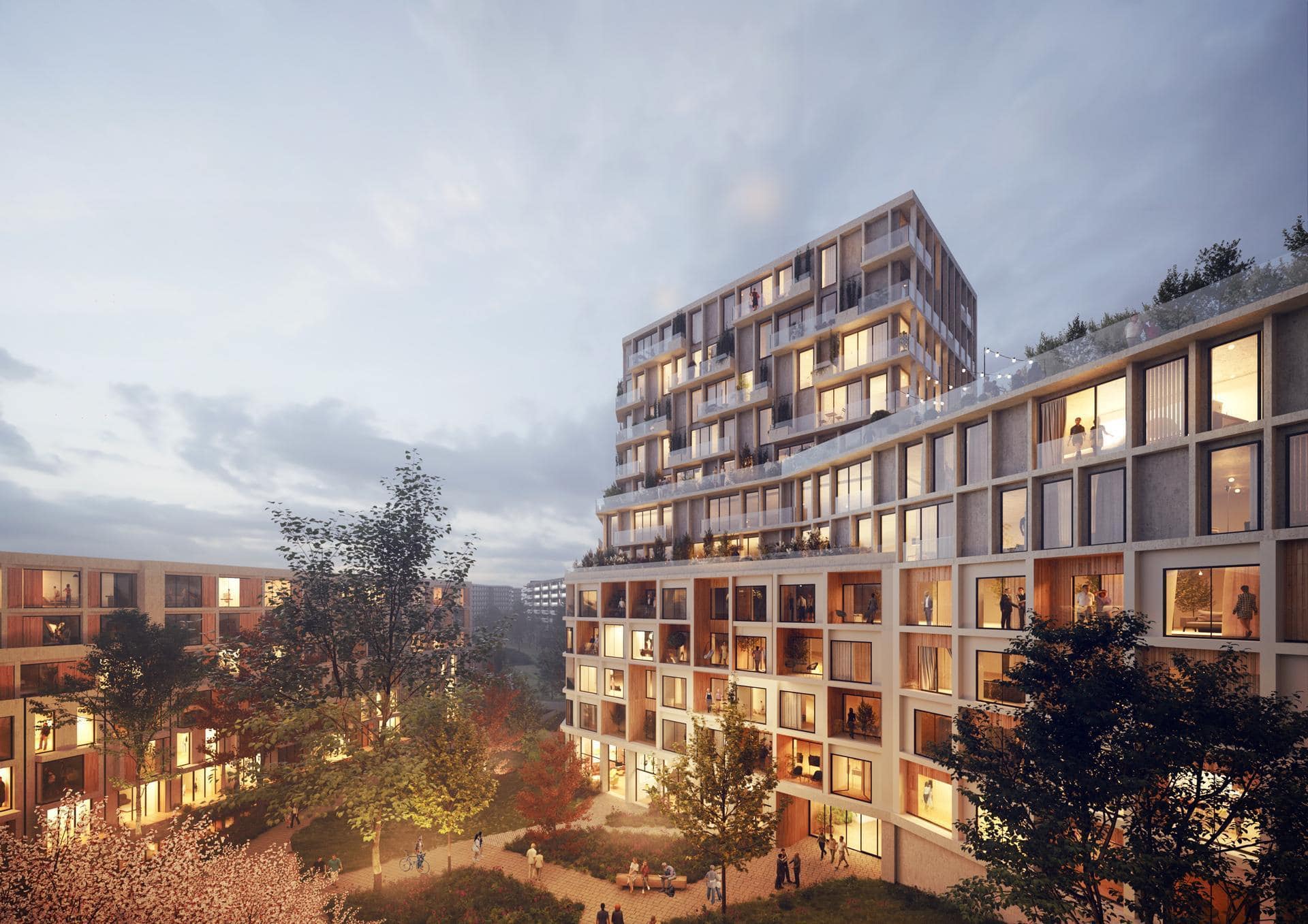


Living at Vondel en de Zwaan, Leiden, Netherlands / Developer: FSD / Real estate developer: FSD / Semi-aerial view at dusk with streetscape and courtyard visualizations in sunshine and on a misty day, showing daily life around the homes, created by RNDR
What Must Architectural Master Planning Visuals Show a Planning Committee?
A committee decides on impact, so an architectural master plan rendering for a committee has one job: make the impact easy to judge. Different types of 3D views do that in different ways, and a committee usually needs all three below.
Aerial and Bird’s-Eye Views for Context
Start with the entire development in its surroundings. One context aerial should answer where the site is, how big it is and what’s around it in about ten seconds: the main road networks, transit stops, schools, the existing city centre and the green corridors the plan connects to. A photorealistic aerial visualization does this better than any map, because it shows the environmental context and the surrounding urban landscape at true scale.
For housing developments, mixed-use districts and university campuses alike, this is the view that tells a committee the whole community has been considered, not just the plot. It’s also the one image the city’s communications team is most likely to publish.
Accurate Views for Height, Massing and Shadow
Next come the views a committee can check. In the UK these are verified views, built from photographs taken at recorded positions, survey data and a scaled model placed exactly into the frame. Even where the law doesn’t ask for them, the method is worth copying for any scheme with tall buildings or sensitive neighbors.
These images should be calm. No sunset, no crowds, realistic textures and honest daylight. Photorealism isn’t the test here. Traceability is. Every view should be traceable to the CAD files, the AutoCAD or SketchUp model and the survey it came from. Shadow studies at the spring equinox and in midwinter answer the most common objection before anyone raises it. And where new buildings meet existing low-rise housing, show that edge from the neighbors’ side, because that’s the view they’ll check.
Phasing Over 5, 10 and 15 Years
A large master plan is built over decades, and committees know that phase one may stand alone for years. Show the phases as master plan 3D views from one fixed camera, dated, with built phases in full color and future phases as lighter massing. People can compare frames without having to reorient themselves each time.
A successful master plan needs phase one to work on its own, and the images should prove it does. We looked at how this plays out on long Canadian build-outs in our article on Toronto aerial rendering for architects and developers. The principle travels well: show what’s certain in detail and what’s uncertain lightly, and say out loud which is which.
Committees approve what they understand. Give yours an aerial for context, accurate views for height and a phasing sequence it can follow.
Malgo, CEO of RNDR
Take Your Master Plan Into the Hearing With Images People Believe
Every master plan gets judged as an image long before it’s judged as a building. A planning officer, a council member, a neighbor and an investor will each decide something based on what they saw in the room, and most of them will never open the architectural plans. A high-quality master plan rendering gives each of them the answer to their own question from the same model.
That’s how we work at RNDR. Many 3D rendering services stop once the images are accurate, and that’s the point where our work gets interesting. As a boutique European 3D rendering studio, we start with accurate, photorealistic master plan views that hold up in front of a planning board. Then we add what makes people care: the season, the light, the neighbors and the daily life the plan was designed for. The master plan rendering carries you from consultation to approval to the first off-plan sale.
If your scheme is heading into public consultation or a committee date, send us your CAD files or 3D model, the phasing schedule and a few lines on who will be in the room. We’ll suggest which views each stage needs and how to tell the visual story from the first aerial to the last eye-level moment.
Frequently Asked Questions About 3D Master Plan Renderings in the Approval Process
How accurate is master plan CGI?
As accurate as the files and method behind it. A detailed master plan rendering built from CAD files, survey data and photographs from recorded positions can be checked against the drawings view by view. Our aerial view rendering services work the same way.
When should you commission master plan 3D visualization?
Earlier than most teams do. Commission simple massing views at concept stage and a consultation set a few weeks before the first public meeting, with accurate views alongside the municipal submission. One early 3D model keeps every later image consistent and speeds up approvals and pre-sales.
Is one aerial rendering enough for a public consultation?
Rarely. Most consultations need five to eight views: one context aerial, one or two before and after pairs from places residents know, two or three eye-level street views, and an option comparison if you’re asking people to choose. Our aerial rendering guide covers the context view. Print everything large and post it online.
What is the process of creating master plan renders?
It starts with the client’s planning concept and a rendering brief based on the urban design master plan guidelines. The studio builds a 3D model from the architectural plans in specialized software, sets camera views for each audience, adds materials, landscaping and people, then finishes the images in post production. Here’s what a full master plan rendering includes.
Are master plan renderings a realistic view of the future?
Partly, and a good image tells you which part. The buildings, heights and layout are measured. The rest is a reasonable forecast: trees take years to grow, materials can change and later phases may shift over a long build-out. Dated frames and labels like “planting at 10 years” keep an image honest.
Who uses master plan architectural visualization during planning and approval?
Each group looks for something different. City planners check massing, density and street connections. Committee members weigh the impact on the neighborhood. Residents want their own street, shade and green space. Developers and investors use the same images to secure funding and present the urban project vision before off-plan sales.
Sources
- Eilola, S., Jaalama, K., Kangassalo, P., Nummi, P., Staffans, A., Fagerholm, N. (2023), 3D visualisations for communicative urban and landscape planning: What systematic mapping of academic literature can tell us of their potential?, Landscape and Urban Planning, Vol. 234
- Ballotpedia (2025), New York, New York, Question 3, Expedited Land Use Review Procedure Charter Amendment
- MLT Aikins (2023), Bill 44: Housing Statutes (Residential Development) Amendment Act, 2023
- Greenberg Traurig Amsterdam Law Blog (2024), New Environment and Planning Act (Omgevingswet)’s ‘Participation Requirement’ Does Not Imply Consensus, Confirms Recent Case Law